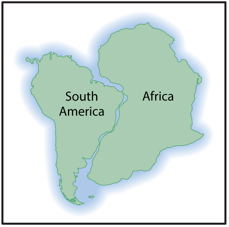
If you look closely at any globe or world map, you’ll probably notice that South America and Africa look like they could easily have been fit together (Figure 5.3–1). The fit is even better if you include their continental shelves , which were once above the surface and can be seen on relief maps such as those in Slide Show 4.8. This might make you wonder: Is this puzzle-like fit a coincidence, or could it be that the two continents actually were together at some time in the past?
(b) This video shows how the two continents could have started out together and “drifted” to their current locations on the globe. Credit: NASA.
Figure 5.3.1–1 – One look at the way South America and Africa seem to fit together might make you wonder if they ever really were together.
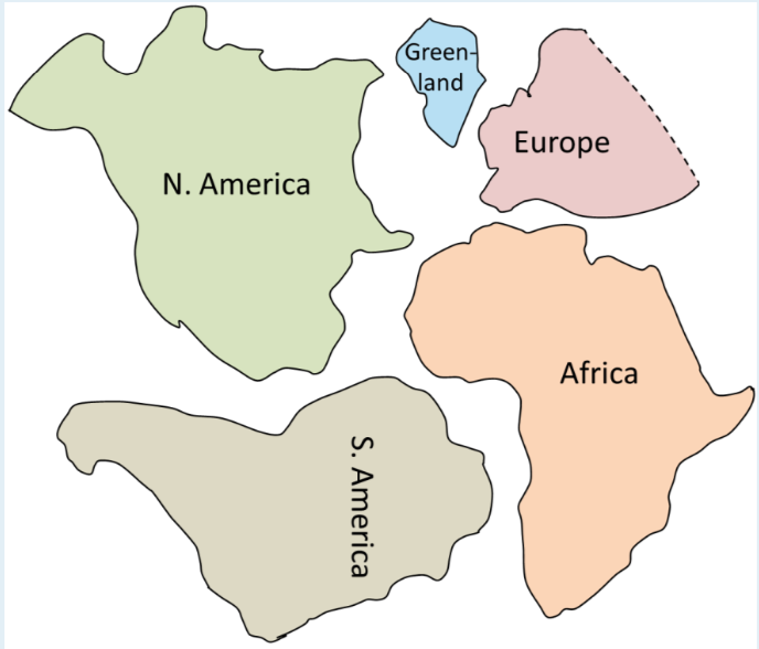
Many people had wondered about this “continental fit” from the time that accurate world maps first became available, but it didn’t become a major topic of scientific debate until the year 1912. That was when a scientist by the name of Alfred Wegener (1880–1930) published a paper proposing not only that Africa and South America had once been together, but that all the continents of the world had once been combined into a single “super-continent” that he later named Pangaea , from Greek words meaning “all land” (Figure 5.3.1–2).
Figure 5.3.1–2 - The starting image shows how the present-day continents once fit together to make the supercontinent of Pangaea. Push play to watch how the continents then “drifted” to their current locations. Credit: USGS.
Activity
Continental Puzzle
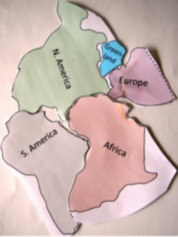
The shapes below represent the major continental regions that lie on either side of the Atlantic Ocean. Print them out and cut them out, and then see if you can get them to fit together as they did in Pangaea. Then study Figure 5.3.1–2 to see if you can also figure out where Asia, Australia, Antarctica, and India would fit into Pangaea. Note: The shapes are a little different from the modern shapes of the continents because they are drawn very approximately and because they include continental shelves, since those were also merged together in Pangaea.
This activity is designed to make the concept of Pangaea more concrete for students by giving them a chance to fit part of it together for themselves. The photo below shows the basic answer (also provided by Steve Earle, as noted in the Activity credit). Students can then compare to Figure 5.3.1–2 to find the locations of the other continents (and India) in relation to their cutouts.
Wegener’s idea required that the continents must have moved — or “drifted” — apart to explain how they got from Pangaea to their current positions on the globe. For this reason, Wegener’s hypothesis is called continental drift .
Today, we know that Wegener’s general idea was correct. In fact, scientists can now use GPS measurements to precisely map out how and how fast the continents are moving around the globe. Nevertheless, his hypothesis did not gain general acceptance until decades after he proposed it, and some prominent scientists attacked the idea, unwilling to accept that the continents might really move. For this reason, it is worth looking at how Wegener’s idea eventually became accepted, since it provides a great example of how modern science makes progress. To help you understand the process, try the following Discussion before you read on.
Discussion
What Would YOU Look for to Support Continental Drift?
Imagine that it is around the year 1900. Like Alfred Wegener, you have been studying the globe and have noticed that the continents look like they might once have been fit together as the supercontinent of Pangaea. You tell some of your friends about this idea, and while they see the same fit, they reply “but it has to be a coincidence, because continents couldn’t really move.” Working in small groups or as a class, make a list of the kinds of additional evidence (besides just the puzzle-like fit) that you might look for in order to convince your friends.
The primary goals of this discussion are: (1) students should recognize that the puzzle-like fit alone could indeed be “just a coincidence” and, by itself, is not enough to support the hypothesis; and (2) students should be able to then consider and list at least a few types of evidence that could strengthen the case for continental drift before we actually discuss this evidence below. Notes:
- If students are having trouble getting started, be sure they understand that the idea of Pangaea had the continents physically connected. That is, despite the fact that figures of Pangaea typically show the outlines of modern continents, no such outlines actually existed — the land on either side of the modern boundaries was physically continuous.
- Once students understand the way the continents were physically connected in Pangaea, they should also be able to realize that this means there were originally no breaks between the now-separated continents. As a result, rock formations, species distributions, and so on would have been continuous across these regions. For that reason, the hypothesis of continental drift predicts that we should see similarities in rock formations, fossils, and etc. between regions that were once connected together. As we’ll discuss below, this fossil and rock evidence was indeed the primary evidence cited by Wegener.
- Students may also come up with some ideas for evidence that, while correct, wouldn’t actually have been testable in the year 1900, such as GPS measurements of motion or analysis of the seafloor to recognize seafloor spreading. For these cases, encourage students to think about how this evidence now “seals the case” for continental motion. You could also have them think about how the unavailability of this evidence at the time may explain why so many scientists were reluctant to accept Wegener’s hypothesis.
- Some students may read ahead or may already know about some of the evidence, but that is OK, as it should only help the discussion along.
Early Evidence for Continental Drift
If you’ve completed the above Discussion, you probably now understand the key to answering the question of whether the puzzle-like fit of the continents is a coincidence or something more: If it’s something more, then we should see additional evidence connecting the continents together.
Figure 5.3.1–3 shows an analogy with jigsaw puzzle pieces: In part (a), we see a fit that is likely coincidental, because aside from fitting together, there is no other obvious connection between the pieces. In contrast, part (b) shows words and art running across the pieces, making it much more obvious that they really do belong together.
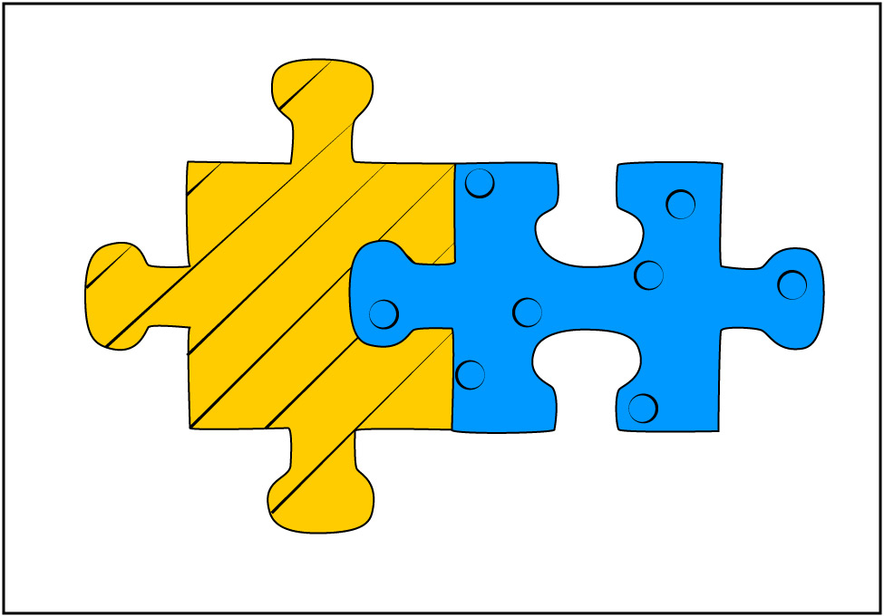
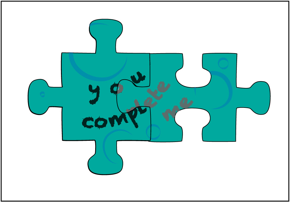
Figure 5.3.1–3 – If different continents really were once joined together, then we should see evidence stretching across them in much the same way as we might see such evidence with jigsaw puzzle pieces.Credit: Zofostro Science.
Wegener actually came up with his hypothesis of continental drift largely because he had read about evidence (collected by others) that made the fit seem like much more than a coincidence. Let’s look at three key types of evidence that he cited.
Mountain Ranges
By the time Wegner published his hypothesis in 1912, geologists had already noticed some striking similarities between the Appalachian mountains of the eastern United States and mountains of the British Islands and of northern Europe. For example, all three ranges have similar structures and rock types, as well as similar ages. Why would such widely separated mountain ranges be so similar to one another?
Wegener’s hypothesis of continental drift answered this question by proposing that the mountains were once all part of a single mountain belt, but they had then drifted apart to their current locations. Figure 5.3.1–4 shows the idea: part (a) shows the current locations of these mountains, and part (b) shows how they would all have been linked in Pangaea.
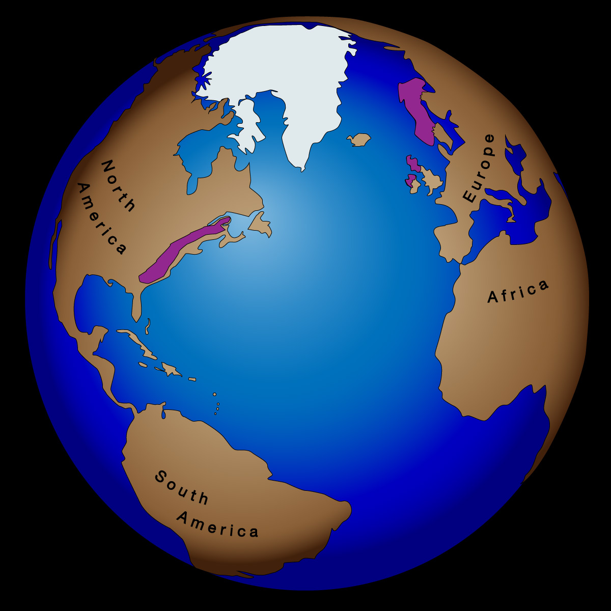
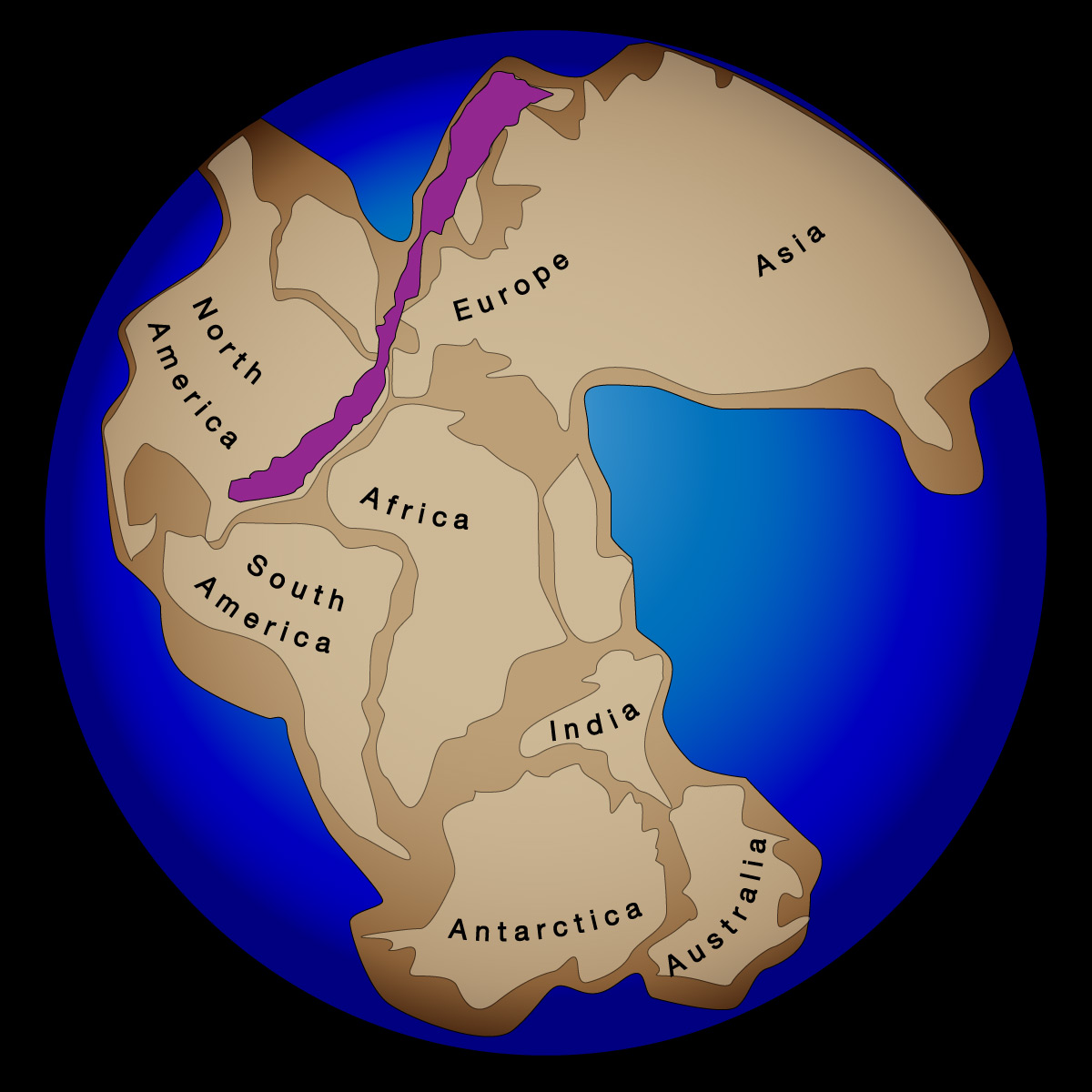
Figure 5.3.1–4 – Like words or art stretching across jigsaw puzzle pieces, mountain chains provided evidence that North America and northern Europe had once been connected. Credit: Zofostro Science.
Ancient Ice Sheets
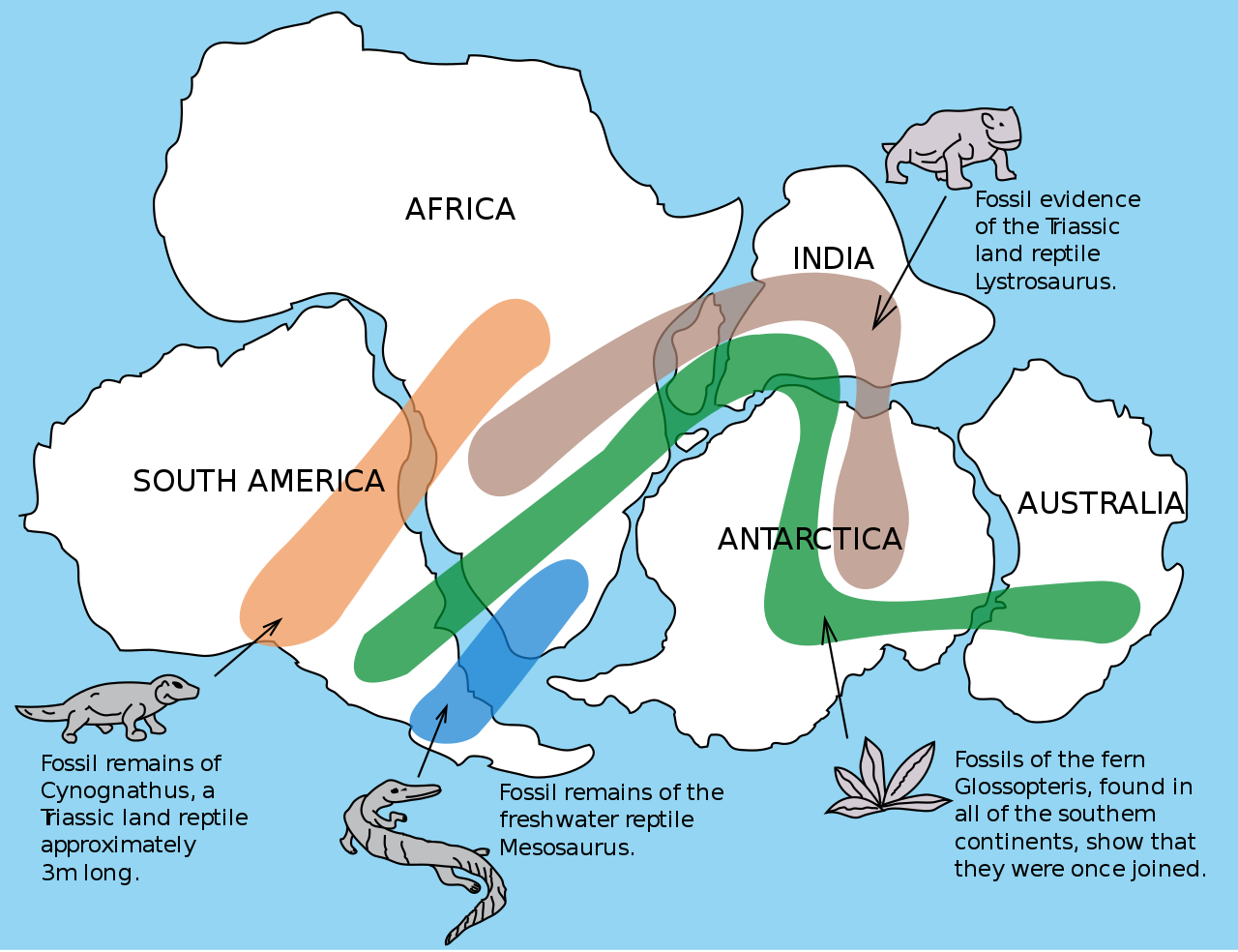
Geologists had also noticed an even more surprising mystery that concerned parts of South America, Africa, Australia, and India. All four of these regions showed substantial evidence of having been covered by huge glaciers at about the same time in the distant past, some 300 million years ago . The great mystery was that, as you can see in Figure 5.3.1–5a, these regions are not only widely separated but some of them are quite close to the equator. How, then, could they ever have been cold enough to have been covered by glaciers?
Again, Wegener used the idea of continental drift to explain this mystery. When he fit the continents together as Pangaea, he found not only that the four regions were all connected, but also that they were all located close to the South Pole. This explained how they could have been cold enough to be covered by ice.
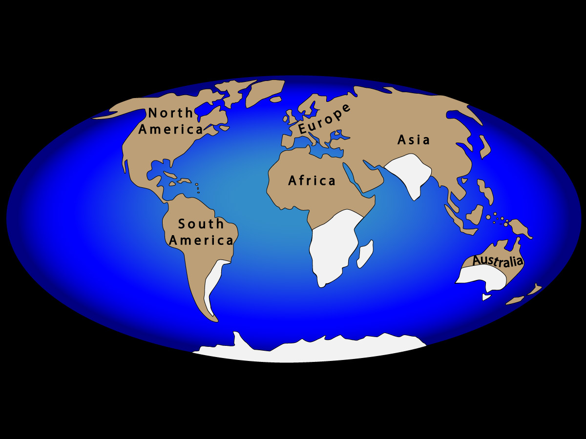
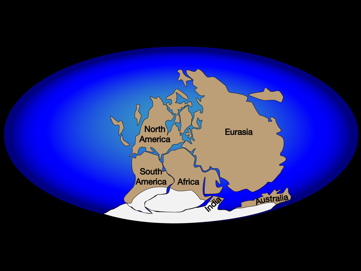
Figure 5.3.1–5 – Additional evidence for the past existence of Pangaea came from studying regions around the world that had been ice-covered around the same time in the distant past. Credit: Zofostro Science.
Discussion
India
Today, we think of India as being part of Asia. However, Figure 5.3.1–5 shows that India was once quite far from the rest of Asia. How does what you see in the figure relate to what you’ve already learned about the Himalayas?
This should be a very brief discussion to help students put together some of the ideas they’ve learned about. The answer is that they already have learned that the Himalayas formed as the plate carrying India collided with the plate carrying the rest of Asia. Figure 5.3.1–5 shows that India actually traveled a long distance to reach the rest of Asia, since it was once far to the south in Pangaea.
Fossil Similarities
Scientists had also discovered that they often found fossils of the same species on continents that are separated by oceans today. For example, fossils of a large reptile called Cynognathus (pronounced “si-nog-ne-thus”) were found both in South America and Africa. This reptile had legs for walking, not fins, so it could not have swum across the Atlantic ocean. How, then, did it get from Africa to South America (or vice versa)?
The existence of Pangaea could also answer this question: they walked, back when Africa and South America were together. Figure 5.3.1–6 shows the distributions of Cynognathus and several other fossils that only make sense if the continents were once connected.
Controversy and Alternative Hypotheses
With modern hindsight, it may seem difficult to argue with the evidence we’ve discussed for Wegener’s hypothesis of continental drift. But the case was less clear at the time, and his hypothesis was very controversial.
Let’s start with the geological evidence, such as the similarities between the mountain ranges of Figure 5.3.1–4 and glacier-covered regions of Figure 5.3.1–5. Today, we know that these similarities are real, in part because absolute dating methods allow us to compare the ages of features found on different continents. But back when Wegener first advanced his hypothesis, much of the “similarity” was based on visual appearances, which can often be deceiving. As a result, it was not so difficult for geologists of the time to imagine that these geological similarities were just coincidental.
The fossil evidence posed a bigger challenge for Wegener’s critics. For example, the fact that fossils of the reptile Cynognathus were found in both South America and Africa meant that this animal really had lived in both places. So if the critics were going to say the continents had not once been together, then they needed an alternative model to explain how the same animal could have lived on both sides of the Atlantic Ocean. The most common alternative suggested that there had once been a “land bridge” connecting the continents, allowing the animals to cross the ocean by walking (Figure 5.3.1–7).
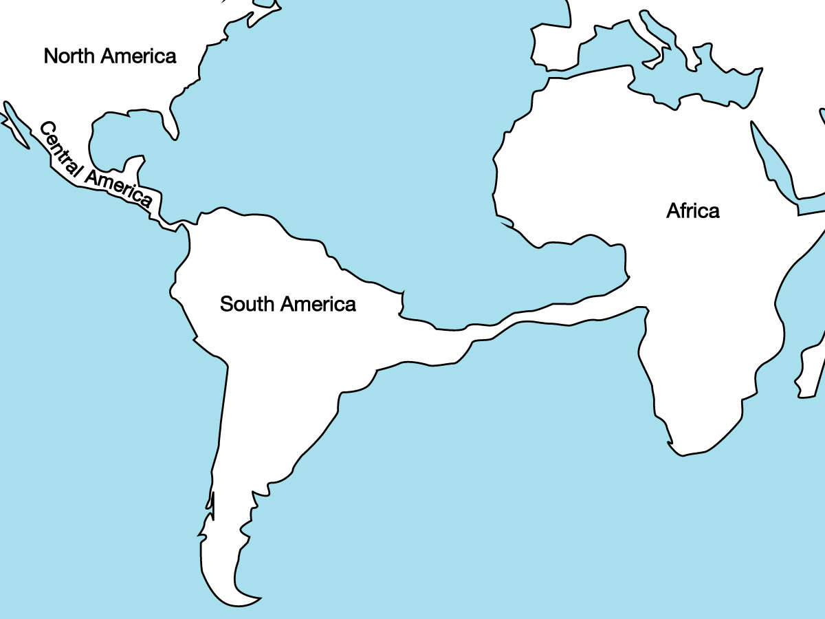
The idea of a bridge between South America and Africa may sound a bit far-fetched today, but it wasn’t so crazy at the time. For example, if you look at a globe or at Figure 5.3.1–7, you’ll see that Central America is essentially a real “land bridge” connecting North and South America. It therefore wasn’t so hard to imagine a longer connection across the Atlantic. Moreover, people in Wegener’s time had already correctly guessed of the past existence of a land bridge connecting Asia and Alaska across what is now the Bering Strait (see Figure 5.2.2–15 and the Connections box “Reaching the Americas”). So again, the idea of a land bridge could have seemed reasonable at the time. The land bridge hypothesis lost favor only later, after it failed to meet a key test: If the land bridge had really existed, then traces of it should still exist beneath the ocean surface. But no such traces were found when the seafloor was first mapped.
Discussion
Floating Across the Ocean
The land bridge was the most common alternative explanation for the fossil evidence, but if you think about it, you’ll realize there’s one other general alternative: Perhaps there’s some way that the land animals could have crossed the ocean. For example, if you live near the ocean, you’ll know that on occasion you see “natural rafts” consisting of logs or other floating debris, so you might imagine that an animal could accidentally float away on such a natural raft. Do you think it is reasonable to imagine that large land animals like Cynognathus crossed the Atlantic Ocean on natural rafts? Why or why not?
This question might generate some interesting discussion, but in general, scientists do not consider an ocean crossing to be a plausible explanation for the fossil evidence because:
- The currents make it unlikely that many natural rafts would ever make the complete Atlantic crossing, and even when they did, the crossing would at minimum take many weeks and more likely many months. This means that most (if not all) animals that got stuck on such natural rafts would die of hunger or dehydration long before reaching the opposite shore.
- Even if an animal somehow managed to survive the trip, a single animal cannot establish a species. It would take many animals, male and female, all arriving in virtually the same place at about the same time in order to establish the species. The odds against this are staggering.
- If there were some way to get around the above issues, so that animals did manage to make the crossing many times, they would certainly have landed in many different places. In that case, we’d find the same fossils much more widely dispersed, rather than in the clear connection patterns shown in Figure 5.3.1–6.
Note that there is one other intermediate hypothesis to a complete land bridge: perhaps there could have been a series of islands that stretched across the ocean, so that the distance between each pair of islands was short enough for animals to have crossed on natural rafts (or perhaps even to have swum). However, this idea is essentially the same as the land bridge idea, except using islands as stepping stones rather than as one continuous link. As with the land bridge, it is ruled out by modern mapping of the ocean floor.
Key Concepts: Evidence is Evidence
This is a great moment to remind you of a critical idea about how science works: If someone presents evidence in support of some model (or theory), you cannot simply reject the model by pretending the evidence doesn’t exist. Instead, you must come up with an alternative and reasonable explanation for the evidence. For the case we are discussing here: Wegener explained both the geological evidence and the fossil evidence by proposing a model in which the continents had once been linked together in Pangaea. His critics came up with alternative explanations: For the geological evidence, their alternative was “coincidence,” which seemed possible at the time because the geological evidence was not 100% clear. The fossil evidence, however, was irrefutable, and they could not make this evidence go away. Therefore, if they rejected Wegener’s model in which the continents had once been together, then they had no choice but to propose a different model by which a land animal could have crossed the Atlantic Ocean. That is why they suggested the idea that there had once been a land bridge that later sank beneath the sea. Of course, this model made its own important prediction: that traces of this land bridge would still exist beneath the ocean surface. This prediction was proven false when Marie Tharp and others mapped the ocean floor. At that point, we knew that the land bridge model was wrong, leaving the idea that the continents had once been together as the only reasonable model for explaining the fossil evidence.
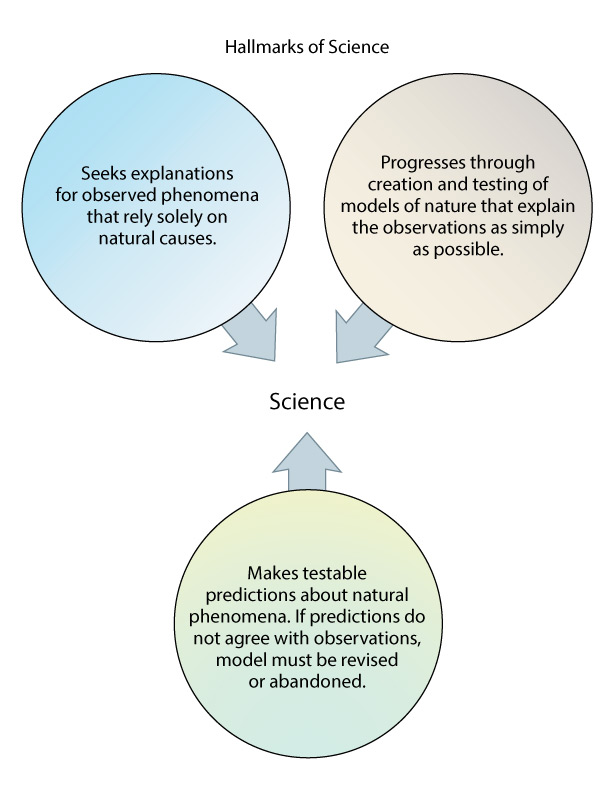
To summarize so far, Wegener’s critics attributed the puzzle-like fit and geological similarities of the continents to coincidence, and the fossil evidence to a land bridge. But to understand the biggest objection of these critics, you must think back to the hallmarks of science that we discussed in Chapter 3 (see Figure 3.16). In particular, focus on the following:
- Hallmark 2 says that: Science progresses through the creation and testing of models of nature that explain the observations as simply as possible.
- Hallmark 3 includes the statement that a scientific model “must make testable predictions about natural phenomena.”
Wegener’s mode of continents “drifting” around the globe made a very clear prediction: It predicted that there must be some force that exists and that is strong enough to move entire continents. This was a very serious problem for Wegner’s model, because he was unable to identify any force that was strong enough to do this. Remember, the fact that Earth’s surface is broken into plates was not yet known, so he and other scientists assumed that the continents had to somehow ram their way through Earth’s crust in order to move around the globe. Wegener proposed various forces that might do this, but none of them worked. For example, at one point he suggested that tides drive continents around the globe, but other scientists quickly did calculations to prove that tides could not provide anywhere near enough force. The lack of a simple explanation for a major prediction of Wegener’s model made many scientists doubt that continents could really move around the globe.
Activity
Debating Continental Drift
Imagine that you are students in the year 1920. Your teacher (in the year 1920) has presented the pros and cons of Alfred Wegener’s recent proposal that continents have drifted to their current positions after having once been linked together in Pangaea. Based on what you have learned, hold a class debate or mock trial in which you decide whether or not you accept the idea of continental drift. To do this, divide your class into three groups:
- Group 1 will go first, defending the model of continental drift.
- Group 2 will go next, arguing against the model of continental drift.
- Group 3 will serve as the jury, deciding which side wins the debate.
Your teacher will serve as the judge, making sure that all groups present and consider only evidence that was available as of the year 1920.
Note: Students in Groups 1 and 2 should take some time to come to agreement within the group on which pieces of evidence support their case most strongly, and in preparing to explain how the evidence supports their argument. Students in Group 3 should discuss the evidence presented before rendering a group verdict on the debate winner.
This activity is another debate or mock trial similar to those in Chapter 3, in which students are asked to consider the merits of Wegener’s hypothesis in the historical context of its time. A few key notes:
- The basic arguments should be fairly straight-forward if students have read and understood the discussion in this section, since the key evidence for both sides has already been discussed. In particular:
- The pro side should be able to cite the puzzle-like fit of the continents and the geological and fossil evidence.
- The con side should be able to cite the alternative explanations we have discussed along with the fact that, at the time, no one knew of a mechanism that could explain how continents could move.
- You should try to help students distinguish between the hypothesis that the continents were once all together in Pangaea and the hypothesis that they “drifted” to their current locations. Wegener saw these two parts of the overall hypothesis as one and the same, but that is no longer the case today. We now know that Wegener was correct about Pangaea, but that the continents do not really “drift” through the crust as he imagined, but instead are carried along on the tectonic plates.
Sealing the Case for Continental Motion
Alfred Wegener knew that he would need much more evidence to convince those who doubted the idea of continental drift. He continued to seek that evidence for the rest of his life, which ended in 1930 during a dangerous research expedition to Greenland. Fortunately, other scientists were also investigating Wegener’s hypothesis, and they continued this work after his death.
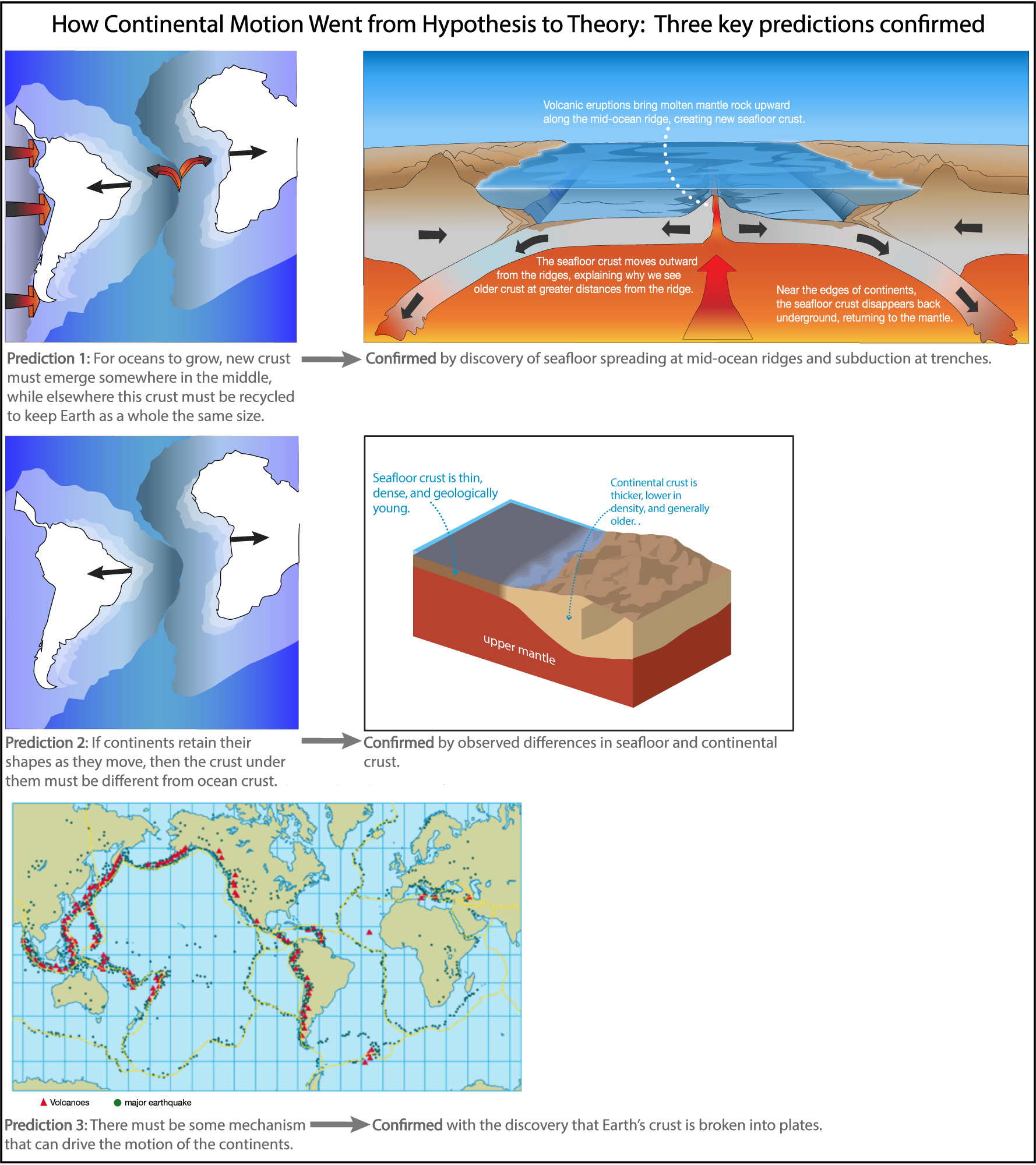
The key breakthrough came as scientists began to study and map the ocean floor. You can understand how the case was sealed by thinking about three other key predictions that scientists recognized to be part of the continental drift model:
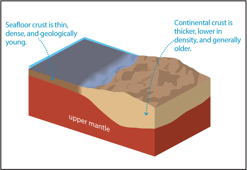
- The first prediction concerned the nature of Earth’s crust. If continents really moved around the globe, then there had to be something that made it possible for them to retain their basic shapes even as oceans opened up between them. In essence, the model predicted that the crust underlying the continents had to be different from that of the oceans, so that the continents could essentially “ride around” as oceans grew or shrank in size.
This prediction was confirmed by the discovery that continental crust and seafloor crust differ as we discussed earlier (see Figure 5.2.1–1).
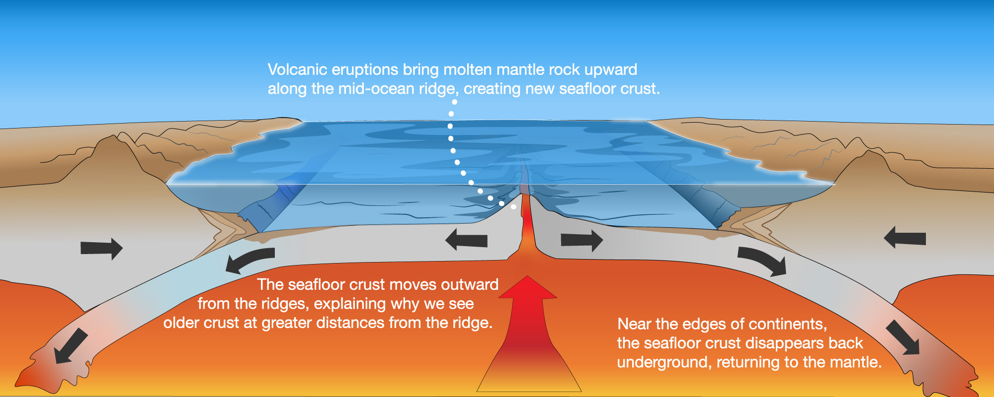
- The second prediction concerned the oceans themselves. If oceans really did open up between continents, then there must be a place in the middle of the oceans where new seafloor crust could form. Moreover, since Earth as a whole is not changing in size, there must be other places where old seafloor crust could be recycled.
This prediction was confirmed with the discovery of seafloor spreading at mid-ocean ridges (see Figure 5.2.1–3) and the subduction of old seafloor at trenches (Figure 5.2.1–4).
- The third prediction was the one that had given Wegener trouble initially: that there had to be some mechanism that could move continents around.
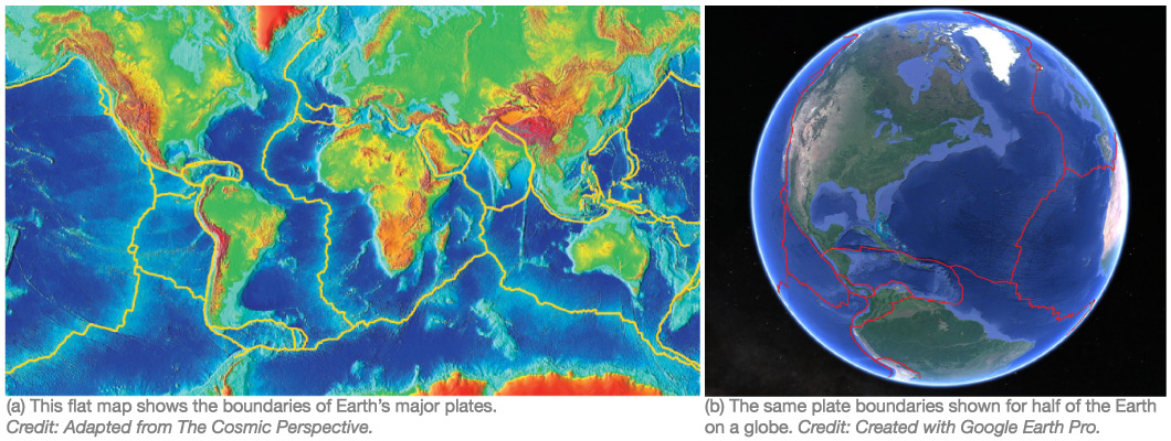
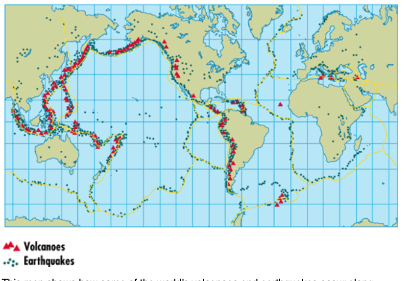
The discovery of seafloor spreading and subduction at trenches, combined with careful study of the distribution of earthquakes and volcanoes around the world (see Figure 5.3–1), showed that Earth’s crust is broken into plates, and calculations quickly showed that the internal heat of Earth itself was sufficient to drive the motions of these plates.
Notice that all three of the confirmed predictions above are key aspects of what we now call plate tectonics (Figure 5.3.1–8). In other words, the discovery of plate tectonics answered all the objections that critics of Wegener’s model had once voiced. As a result, by the late-1960s, the idea that continents move around the globe with time was no longer “just a hypothesis.” Instead, it was supported by such overwhelming evidence that it became accepted as true in the context of the scientific theory of plate tectonics.
Discussion
Was Wegener Right or Wrong?
We now know that Alfred Wegener was clearly correct in his claim that the continents had all once been merged together in Pangaea. However, he did not know how the continents moved around the globe, and the ideas he proposed (such as continents “plowing” through the Earth’s crust) are quite different from the way we now understand continental motion to arise from plate tectonics. So would you say that his idea of “continental drift” was right, wrong, or something in between? Defend your opinion.
This can be a brief discussion, as the answer is really a matter of opinion. The key is that students should now recognize that Wegener was right about continental motion, but this was not enough to make his idea count as a scientific theory until a mechanism for it was discovered. And that mechanism — plate tectonics — is quite different from anything Wegener himself had thought of. You might want to refer back to our discussion in Section 3.4.1 of how Newton’s theory of gravity relates to Einstein’s, which may provide a useful analogy, since Einstein gives a very different picture of how gravity works, but in most cases Newton’s theory still gives the correct answers.
Today, there is no longer any doubt that the continents really do move around with time, because scientists can use GPS to measure their motions (Video 5.3.1–9). The speeds are only a few centimeters per year — which is about the rate at which your fingernails grow — but they can completely rearrange the globe over tens and hundreds of millions of years.
Video 5.3.1–9 – This video summarizes how scientists now use GPS to confirm that continents move. It also shows an example of how these measurements allow scientists to understand earthquake danger. Credit: UNAVCO.
Claim-Evidence-Reasoning Activity
Earth’s Changing Map
Based on everything you have learned so far, construct a detailed argument using evidence and reasoning to support the following claim:
Claim: The current arrangement of the continents on Earth is only temporary. The arrangement was very different in the distant past and will be different again in the distant future.
This activity asks students to use the CER format to demonstrate that they’ve understood the scientific evidence that demonstrates beyond reasonable doubt that the continents really have moved with time. If you grade the activity, look for students to organize the evidence that we have discussed into a clear, well-reasoned argument